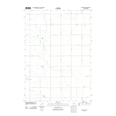
2012 Map of Fraser Dam
USGS Topo · Published 2012About this map
Firesteel Creek meanders through this agricultural landscape in Jerauld County, serving as the primary hydrological spine of the region. The map reveals a structured grid of rural section lines defined by routes like 234th St and 389th Ave, which connect isolated homesteads and community landmarks. Local history and genealogy are centered on three distinct burial grounds: Solberg Cemetery, German Cemetery, and Charity Cemetery, each situated along these gravel thoroughfares. To the southwest, the impoundment of the creek at Fraser Dam creates Lake Fraser, a notable water feature amidst the surrounding terrain characterized by natural drainage features such as Motts Draw, Piersons Draw, and Donegans Draw. These topographic depressions illustrate the intricate drainage patterns of the Dakota prairie.
Find a feature on this map
23 named features on this map. Tap any name to fly to it.
Don’t see what you’re looking for? This feature index may not catch every label — zoom into the map to look around manually.
Map Details
Editions of this 2012 Fraser Dam Map
This is the sole edition of this map. No revisions or reprints were ever made.
Other maps of this area

1898 · Huron
USGS Topo · 1:125,000

1899 · Mitchell
USGS Topo · 1:125,000

1942 · Crow Lake
USGS Topo · 1:62,500

1953 · Huron
USGS Topo · 1:250,000

1954 · Huron
USGS Topo · 1:250,000

1955 · Mitchell
USGS Topo · 1:250,000

1959 · Mitchell
USGS Topo · 1:250,000
1973 · Woonsocket
USGS Topo · 1:24,000

1973 · Wessington Springs
USGS Topo · 1:24,000
1973 · Lane
USGS Topo · 1:24,000