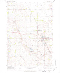
1973 Map of Woonsocket
USGS Topo · Published 1976About this map
Woonsocket serves as the focal point of this Sanborn County landscape, where the Chicago Milwaukee St Paul and Pacific railroad bisects the prairie. The town's layout is defined by its proximity to water and recreation, featuring the City Park and a local Golf Course. To the south, the terrain transitions into the Mc Coy Lake State Public Shooting Area surrounding McCoy Lake, illustrating the regional importance of managed wetlands and public hunting grounds. For genealogists and local historians, several burial sites are documented, including St Wilfrid Cem, Eventide Cem, and the more remote Forstner Cem to the southwest. The presence of an Old RR Grade and numerous Gravel Pits reflects the local infrastructure and resource extraction common in this part of South Dakota during the early 1970s.
Find a feature on this map
27 named features on this map. Tap any name to fly to it.
Don’t see what you’re looking for? This feature index may not catch every label — zoom into the map to look around manually.
Map Details
Editions of this 1973 Woonsocket Map
This is the sole edition of this map. No revisions or reprints were ever made.
Other maps of this area

1898 · Huron
USGS Topo · 1:125,000

1899 · Mitchell
USGS Topo · 1:125,000

1953 · Huron
USGS Topo · 1:250,000

1954 · Huron
USGS Topo · 1:250,000

1955 · Mitchell
USGS Topo · 1:250,000

1958 · Forestburg NW
USGS Topo · 1:24,000

1959 · Mitchell
USGS Topo · 1:250,000

1973 · Alpena
USGS Topo · 1:24,000
1973 · Forestburg SW
USGS Topo · 1:24,000
1973 · Woonsocket NW
USGS Topo · 1:24,000