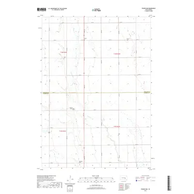
2017 Map of Fraser Dam
USGS Topo · Published 2017About this map
Firesteel Creek meanders through this portion of the South Dakota prairie, defining a landscape of low drainage draws and scattered pioneer burial grounds. The map reveals the rural infrastructure of Blaine Township and the surrounding area at the Jerauld and Aurora county line, where the local economy is etched into the earth through features like Fraser Dam. This 2017 edition serves as a detailed record of the township's section lines and persistent family landmarks, including several small cemeteries that speak to the area's genealogical history. Researchers can find Solberg Cem, German Cem, Charity Cem, and Union Cem distributed across the sections, while natural features like Piersons Draw Motts Draw and Donegans Draw provide specific context for the region's topography and drainage patterns.
Find a feature on this map
31 named features on this map. Tap any name to fly to it.
Don’t see what you’re looking for? This feature index may not catch every label — zoom into the map to look around manually.
Map Details
Editions of this 2017 Fraser Dam Map
This is the sole edition of this map. No revisions or reprints were ever made.
Other maps of this area

1898 · Huron
USGS Topo · 1:125,000

1899 · Mitchell
USGS Topo · 1:125,000

1942 · Crow Lake
USGS Topo · 1:62,500

1953 · Huron
USGS Topo · 1:250,000

1954 · Huron
USGS Topo · 1:250,000

1955 · Mitchell
USGS Topo · 1:250,000

1959 · Mitchell
USGS Topo · 1:250,000
1973 · Woonsocket
USGS Topo · 1:24,000

1973 · Wessington Springs
USGS Topo · 1:24,000
1973 · Lane
USGS Topo · 1:24,000