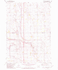
1979 Map of Fraser Dam
USGS Topo · Published 1980About this map
Firesteel Creek winds through this rural South Dakota landscape, defining the topography across the borders of Jerauld and Aurora Counties. In the late 1970s, the area's social geography was anchored by community landmarks such as a rural Townhall and several denominational resting places, including Solberg Cem, German Cem, and Charity Cem. The map reveals a land shaped by intermittent drainage, evidenced by family-named terrain features like Piersons Draw, Motts Draw, and Donegans Draw. Agricultural and small-scale industrial life is visible through the network of section-line roads and scattered Gravel Pit locations. At the heart of the local water system is Fraser Dam, which provides a focal point for the surrounding townships of Viola, Blaine, Bristol, and Belford. Small red dashed lines on the sheet indicate fence and field boundaries, offering an unusually granular look at the rural property divisions of the era.
Find a feature on this map
17 named features on this map. Tap any name to fly to it.
Don’t see what you’re looking for? This feature index may not catch every label — zoom into the map to look around manually.
Map Details
Editions of this 1979 Fraser Dam Map
This is the sole edition of this map. No revisions or reprints were ever made.
Other maps of this area

1898 · Huron
USGS Topo · 1:125,000

1899 · Mitchell
USGS Topo · 1:125,000

1942 · Crow Lake
USGS Topo · 1:62,500

1953 · Huron
USGS Topo · 1:250,000

1954 · Huron
USGS Topo · 1:250,000

1955 · Mitchell
USGS Topo · 1:250,000

1959 · Mitchell
USGS Topo · 1:250,000
1973 · Woonsocket
USGS Topo · 1:24,000

1973 · Wessington Springs
USGS Topo · 1:24,000
1973 · Lane
USGS Topo · 1:24,000