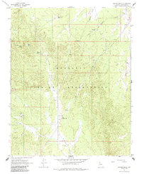
1967 Map of Frazier Wells
USGS Topo · Published 1985About this map
Frazier Wells serves as a central landmark within the Hualapai Indian Reservation on this 1967 survey. The landscape is defined by the vital water management infrastructure of the high plateau, where Numerous tanks and springs support life in the arid Coconino County terrain. The placement of Youth Camp Tank and the high elevation of the Thornton Lookout Tower WT suggest a region managed for both communal use and fire observation.
Find a feature on this map
24 named features on this map. Tap any name to fly to it.
Don’t see what you’re looking for? This feature index may not catch every label — zoom into the map to look around manually.
Map Details
Editions of this 1967 Frazier Wells Map
2 editions found
Other maps of this area

1886 · Diamond Creek
USGS Topo · 1:250,000

1886 · Chino
USGS Topo · 1:250,000

1891 · Chino
USGS Topo · 1:250,000

1892 · Diamond Creek
USGS Topo · 1:250,000

1948 · Williams
USGS Topo · 1:250,000

1954 · Williams
USGS Topo · 1:250,000

1956 · Williams
USGS Topo · 1:250,000

1960 · Williams
USGS Topo · 1:250,000

1961 · Williams
USGS Topo · 1:250,000
1967 · Hockey Puck Spring
USGS Topo · 1:24,000