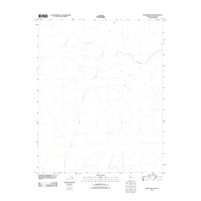
2011 Map of Frazier Wells SW
USGS Topo · Published 2011About this map
Diamond Creek dominates this arid landscape in Coconino County, carving a complex drainage network that defines the region's topography. The map illustrates a remote Arizona territory where water management is central to the land's utility, marked by features such as Pothole Tank, Pinnacle Tank, and Pocomate Springs. Human presence is sparse but specific, centered around the D S Ranch in the northern portion of the quadrangle. Transportation is limited to rugged routes like Indian Service Road 13, which traverses the eastern terrain. This 2011 survey captures the intersection of ranching life and the critical natural water sources required to sustain it within the high desert environment.
Find a feature on this map
6 named features on this map. Tap any name to fly to it.
Don’t see what you’re looking for? This feature index may not catch every label — zoom into the map to look around manually.
Map Details
Editions of this 2011 Frazier Wells SW Map
This is the sole edition of this map. No revisions or reprints were ever made.
Other maps of this area

1886 · Diamond Creek
USGS Topo · 1:250,000

1892 · Diamond Creek
USGS Topo · 1:250,000

1948 · Williams
USGS Topo · 1:250,000

1954 · Williams
USGS Topo · 1:250,000

1956 · Williams
USGS Topo · 1:250,000

1960 · Williams
USGS Topo · 1:250,000

1961 · Williams
USGS Topo · 1:250,000
1967 · Hockey Puck Spring
USGS Topo · 1:24,000
1967 · Frazier Wells
USGS Topo · 1:24,000
1967 · Granite Park
USGS Topo · 1:24,000