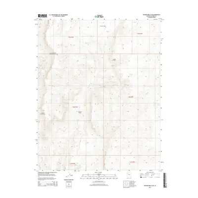
2014 Map of Frazier Wells SW
USGS Topo · Published 2014About this map
Aubrey Cliffs dominate the eastern reaches of this Coconino County terrain, creating a dramatic vertical drop into the drainage basins below. This 2014 survey captures a landscape defined by its complex hydrology and massive canyon systems, such as the curiously named Two Hundred and Seventeenmile Canyon in the northwest. Water management in this arid environment is evidenced by the placement of infrastructure like Pinnacle Tank and Pothole Tank, alongside natural features like Pocomate Springs. Centrally, Diamond Cr carves through Diamond Canyon, illustrating the erosive forces that have shaped Prospect Valley. To the west, Granite Spring Canyon provides further evidence of the deep dissection of the plateau, offering a detailed record of the physical geography of this portion of Northern Arizona.
Find a feature on this map
15 named features on this map. Tap any name to fly to it.
Don’t see what you’re looking for? This feature index may not catch every label — zoom into the map to look around manually.
Map Details
Editions of this 2014 Frazier Wells SW Map
This is the sole edition of this map. No revisions or reprints were ever made.
Other maps of this area

1886 · Diamond Creek
USGS Topo · 1:250,000

1892 · Diamond Creek
USGS Topo · 1:250,000

1948 · Williams
USGS Topo · 1:250,000

1954 · Williams
USGS Topo · 1:250,000

1956 · Williams
USGS Topo · 1:250,000

1960 · Williams
USGS Topo · 1:250,000

1961 · Williams
USGS Topo · 1:250,000
1967 · Hockey Puck Spring
USGS Topo · 1:24,000
1967 · Frazier Wells
USGS Topo · 1:24,000
1967 · Granite Park
USGS Topo · 1:24,000