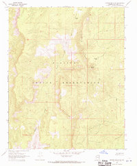
1967 Map of Frazier Wells SW
USGS Topo · Published 1970About this map
The Hualapai Indian Reservation dominates this 1967 survey of northern Arizona, where the landscape is defined by the dramatic ascent of the Aubrey Cliffs. These escarpments create a stark vertical boundary across the quadrangle, influencing the few signs of human habitation and water management in this arid region. The D S Ranch sits near the northern edge, while the site marked Manzanita provides a rare named point of reference among the high elevations. Water access is critical for the ranching and tribal lands shown here, documented by features like Pothole Tank, Pinnacle Tank, and Pocomate Springs. A winding Diamond Creek cuts through the southwestern corner, joined by a network of unimproved roads and a Jeep Trail that navigated this difficult terrain before modern infrastructure arrived.
Find a feature on this map
9 named features on this map. Tap any name to fly to it.
Don’t see what you’re looking for? This feature index may not catch every label — zoom into the map to look around manually.
Map Details
Editions of this 1967 Frazier Wells SW Map
This is the sole edition of this map. No revisions or reprints were ever made.
Other maps of this area

1886 · Diamond Creek
USGS Topo · 1:250,000

1892 · Diamond Creek
USGS Topo · 1:250,000

1948 · Williams
USGS Topo · 1:250,000

1954 · Williams
USGS Topo · 1:250,000

1956 · Williams
USGS Topo · 1:250,000

1960 · Williams
USGS Topo · 1:250,000

1961 · Williams
USGS Topo · 1:250,000
1967 · Hockey Puck Spring
USGS Topo · 1:24,000
1967 · Frazier Wells
USGS Topo · 1:24,000
1967 · Granite Park
USGS Topo · 1:24,000