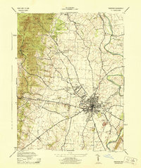
1944 Map of Frederick
USGS Topo · Published 1944About this map
Catoctin Mountain dominates the western landscape of this mid-century survey, where the heights of High Knob and Seventoot Rock overlook the expanding valley below. The city of Frederick serves as a dense terminal for regional transport, anchored by the Baltimore and Ohio RR and the Pennsylvania RR. A specialized industrial and civic footprint is visible in the outskirts, from the Ox Fibre Brush Co Tank and M J Grove Lime Co to the County Hospital & Almshouse.
Find a feature on this map
56 named features on this map. Tap any name to fly to it.
Don’t see what you’re looking for? This feature index may not catch every label — zoom into the map to look around manually.
Map Details
Editions of this 1944 Frederick Map
This is the sole edition of this map. No revisions or reprints were ever made.
Other maps of this area

1884 · Harpers Ferry
USGS Topo · 1:125,000

1891 · Harpers Ferry
USGS Topo · 1:125,000

1893 · Frederick
USGS Topo · 1:125,000

1893 · Harpers Ferry
USGS Topo · 1:125,000

1894 · Frederick
USGS Topo · 1:125,000

1908 · Middletown
USGS Topo · 1:48,000

1908 · Ijamsville
USGS Topo · 1:62,500

1909 · Ijamsville
USGS Topo · 1:62,500

1909 · Hagerstown
USGS Topo · 1:48,000

1910 · Antietam
USGS Topo · 1:62,500