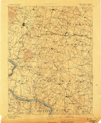
1894 Map of Frederick
USGS Topo · Published 1903About this map
Frederick stands as the central hub of this late 19th-century landscape, where the Baltimore & Ohio R. R. weaves through a network of established agricultural settlements. The terrain is defined by the prominent Sugar Loaf Mtn. and a complex drainage system including Linganore Creek and the South Branch Patapsco River. The map reveals the critical importance of river crossings before modern bridging, documenting numerous river points such as Spinks Ferry and Edwards Ferry. Along the rail lines, specialized stops like Bartholow Switch and Plane No.4 indicate the industrial and logistical requirements of the era's transportation network. From the larger township of Libertytown to smaller hamlets like Araby and Hyattstown, the map provides a comprehensive view of the rural Maryland and Virginia borderlands at the close of the century.
Find a feature on this map
183 named features on this map. Tap any name to fly to it.
Don’t see what you’re looking for? This feature index may not catch every label — zoom into the map to look around manually.
Map Details
Editions of this 1894 Frederick Map
5 editions found

Other maps of this area

1884 · Harpers Ferry
USGS Topo · 1:125,000

1890 · Mt. Vernon
USGS Topo · 1:125,000

1891 · Harpers Ferry
USGS Topo · 1:125,000

1891 · Mt. Vernon
USGS Topo · 1:125,000

1892 · Laurel
USGS Topo · 1:62,500

1892 · Ellicott
USGS Topo · 1:62,500

1893 · Frederick
USGS Topo · 1:125,000

1893 · Harpers Ferry
USGS Topo · 1:125,000

1894 · Ellicott
USGS Topo · 1:62,500

1894 · Laurel
USGS Topo · 1:62,500