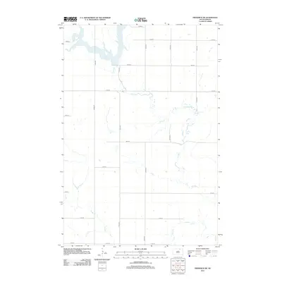
2012 Map of Frederick SW
USGS Topo · Published 2012About this map
Elm Lake dominates the northern reaches of this Brown County landscape, where the waters are fed and drained by the meandering Elm River. The terrain is defined by a rigid section-line road grid, including 375th Ave and 105th St, which speaks to the enduring agrarian structure of Palmyra Township. While modern infrastructure like Co Hwy-2 provides transit across the northern border, the southern half of the map is characterized by the seasonal drainage of Dry Run. This 2012 survey illustrates the intersection of vital water resources and the disciplined land-use patterns common to the South Dakota plains, preserving the exact placement of rural access roads and natural watercourses as they existed at the start of the decade.
Find a feature on this map
18 named features on this map. Tap any name to fly to it.
Don’t see what you’re looking for? This feature index may not catch every label — zoom into the map to look around manually.
Map Details
Editions of this 2012 Frederick SW Map
This is the sole edition of this map. No revisions or reprints were ever made.
Other maps of this area

1894 · Ellendale
USGS Topo · 1:62,500

1899 · Ellendale
USGS Topo · 1:125,000

1952 · Richmond NE
USGS Topo · 1:24,000

1953 · Frederick
USGS Topo · 1:24,000

1953 · Ellendale South
USGS Topo · 1:24,000

1954 · Aberdeen
USGS Topo · 1:250,000

1956 · Aberdeen
USGS Topo · 1:250,000
1968 · Frederick NW
USGS Topo · 1:24,000

1968 · Forbes
USGS Topo · 1:24,000

1968 · Forbes SE
USGS Topo · 1:24,000