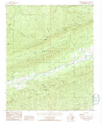
1985 Map of Freedom Mountain
USGS Topo · Published 1986About this map
Ouachita National Forest covers much of this landscape in Scott County, where the southern reaches of Petit Jean Mountain meet the high ridges of Freedom Mountain. The terrain is characterized by a series of parallel ridges and hollows, including Suck Hollow and Coffee Pot Hol, which funnel numerous tributaries like Kingdoodle Creek and Whetstone Creek into the larger valley of Dutch Creek.
Find a feature on this map
37 named features on this map. Tap any name to fly to it.
Don’t see what you’re looking for? This feature index may not catch every label — zoom into the map to look around manually.
Map Details
Editions of this 1985 Freedom Mountain Map
This is the sole edition of this map. No revisions or reprints were ever made.
Other maps of this area

1879 · Mountain Home
USGS Topo · 1:62,500

1887 · Magazine Mountain #4
USGS Topo · 1:62,500

1887 · Mount Ida #2
USGS Topo · 1:62,500

1887 · Magazine Mountain #3
USGS Topo · 1:62,500

1887 · Magazine Mountain
USGS Topo · 1:62,500

1890 · Magazine Mountain
USGS Topo · 1:125,000

1890 · Mount Ida
USGS Topo · 1:125,000

1934 · Booneville
USGS Topo · 1:48,000

1939 · Booneville
USGS Topo · 1:62,500

1955 · Little Rock
USGS Topo · 1:250,000