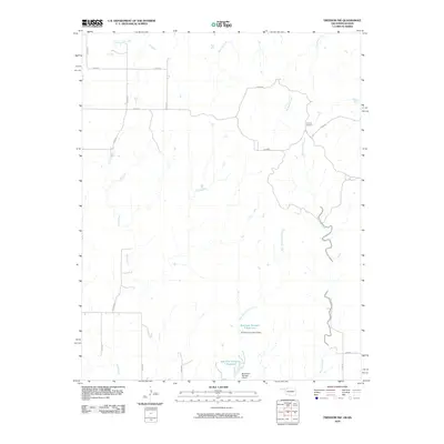
2010 Map of Freedom NW
USGS Topo · Published 2010About this map
Moccasin Creek and its tributary West Moccasin Creek snake through this section of Woods County, defining a landscape shaped by water management and rural cattle heritage. The presence of the Cowboy Cemetery near d0032 RD offers a poignant touchstone for genealogists and local historians, anchoring the area's identity to its ranching roots. This 2010 survey by the U.S. Geological Survey highlights a network of essential water resources, including the Burnham Number 9 Reservoir and Burnham Number 4 Reservoir, secured by the Burnham Number 9 Dam and Burnham Number 4 Dam. A sparse but functional grid of section-line roads like e0020 RD and n2130 RD connects the wide-open drainage basins of Sand Creek and Mustang Creek, illustrating the late-twentieth-century infrastructure of the Oklahoma prairie.
Find a feature on this map
23 named features on this map. Tap any name to fly to it.
Don’t see what you’re looking for? This feature index may not catch every label — zoom into the map to look around manually.
Map Details
Editions of this 2010 Freedom NW Map
This is the sole edition of this map. No revisions or reprints were ever made.
Other maps of this area

1892 · Coldwater
USGS Topo · 1:125,000

1955 · Woodward
USGS Topo · 1:250,000

1955 · Pratt
USGS Topo · 1:250,000

1958 · Woodward
USGS Topo · 1:250,000

1959 · Pratt
USGS Topo · 1:250,000

1970 · Lookout
USGS Topo · 1:24,000

1970 · Freedom NE
USGS Topo · 1:24,000

1970 · Freedom NW
USGS Topo · 1:24,000

1970 · Edith
USGS Topo · 1:24,000
1970 · Freedom
USGS Topo · 1:24,000