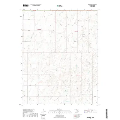
2018 Map of Freedom NW
USGS Topo · Published 2018About this map
Cowboy Cem stands as a lonely landmark in the northeastern reaches of this survey, surrounded by the intricate drainage networks of northern Woods Co. The landscape is defined by the erosion-carved tributaries of the Cimarron River watershed, including the winding paths of Cottonwood Cr, Mustang Cr, and Jug Motte Cr. Human intervention in this arid terrain is evidenced by water management features like Burnham Number 9 Reservoir and Burnham Number 4 Reservoir in the southern sections.
Find a feature on this map
30 named features on this map. Tap any name to fly to it.
Don’t see what you’re looking for? This feature index may not catch every label — zoom into the map to look around manually.
Map Details
Editions of this 2018 Freedom NW Map
This is the sole edition of this map. No revisions or reprints were ever made.
Other maps of this area

1892 · Coldwater
USGS Topo · 1:125,000

1955 · Woodward
USGS Topo · 1:250,000

1955 · Pratt
USGS Topo · 1:250,000

1958 · Woodward
USGS Topo · 1:250,000

1959 · Pratt
USGS Topo · 1:250,000

1970 · Lookout
USGS Topo · 1:24,000

1970 · Freedom NE
USGS Topo · 1:24,000

1970 · Freedom NW
USGS Topo · 1:24,000

1970 · Edith
USGS Topo · 1:24,000
1970 · Freedom
USGS Topo · 1:24,000