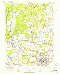
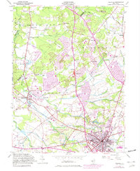
1953 Map of Freehold
USGS Topo · Published 1955About this map
The Monmouth County seat at Freehold serves as the focal point for this mid-century portrait of central New Jersey. The landscape is defined by its colonial-era legacy and water-driven history, seen in the numerous mill settlements like Mounts Mills, Taylors Mills, and Lafayette Mills that line the many brooks feeding into Matchaponix Brook. The Central RR of New Jersey and the Pennsylvania railroad lines provide the primary infrastructure through which the region's agricultural and social life flows.
Find a feature on this map
50 named features on this map. Tap any name to fly to it.
Don’t see what you’re looking for? This feature index may not catch every label — zoom into the map to look around manually.
Map Details
Editions of this 1953 Freehold Map
5 editions found
Other maps of this area

1888 · New Brunswick
USGS Topo · 1:62,500

1888 · Asbury Park
USGS Topo · 1:62,500

1888 · Cassville
USGS Topo · 1:62,500

1888 · Sandy Hook
USGS Topo · 1:62,500

1893 · New Brunswick
USGS Topo · 1:62,500

1893 · Sandy Hook
USGS Topo · 1:62,500

1893 · Asbury Park
USGS Topo · 1:62,500

1894 · Cassville
USGS Topo · 1:62,500

1900 · Cassville
USGS Topo · 1:62,500

1901 · New Brunswick
USGS Topo · 1:62,500
Featured Places
- Old Bridge Township, NJ
- Monroe Township, NJ
- Marlboro Township, NJ
- Manalapan Township, NJ
- Freehold Township, NJ