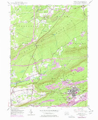
1948 Map of Freeland
USGS Topo · Published 1977About this map
The borough of Freeland and its surrounding coal-patch towns dominate this southern Luzerne County landscape, where the anthracite industry's footprint is deeply etched into the earth. By the mid-20th century, the expansion of Strip Mine operations and massive Mine Dump features had reshaped the terrain between Buck Mountain and Green Mountain. The map records a dense network of local landmarks, from the Good Shepherd Ch near Drums to the curiously named Honey Hole along Nescopeck Creek.
Find a feature on this map
66 named features on this map. Tap any name to fly to it.
Don’t see what you’re looking for? This feature index may not catch every label — zoom into the map to look around manually.
Map Details
Editions of this 1948 Freeland Map
Other maps of this area

1889 · Hazleton
USGS Topo · 1:62,500

1891 · Wilkesbarre
USGS Topo · 1:62,500

1891 · Hazleton
USGS Topo · 1:62,500

1892 · Mahanoy
USGS Topo · 1:62,500

1893 · Hazleton
USGS Topo · 1:62,500

1893 · Mahanoy
USGS Topo · 1:62,500

1894 · Shickshinny
USGS Topo · 1:62,500

1894 · Wilkesbarre
USGS Topo · 1:62,500

1943 · Scranton
USGS Topo · 1:125,000

1944 · Newark
USGS Topo · 1:250,000