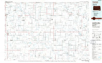
1985 Map of Freeman
USGS Topo · Published 1985About this map
Agricultural settlements and distinct communal outposts characterize this portion of Southeast South Dakota in the mid-1980s. The landscape is notably marked by several Hutterite colonies, including New Elm Springs Colony, Tschetter Colony, and Wolf Creek Colony, which speak to the region's specific heritage of collective farming and land use. The James River winds through the western half of the map, carving a path through townships like Wittenberg and Milltown. This survey captures a network of small grain-handling centers and rural hubs linked by the Burlington Northern and Chicago and Northwestern railroads. While larger towns like Freeman and Parker serve as commercial anchors, the map reveals the density of smaller, localized names such as Gagna Station and Vedin Corner that define the county's social geography during this era.
Find a feature on this map
137 named features on this map. Tap any name to fly to it.
Don’t see what you’re looking for? This feature index may not catch every label — zoom into the map to look around manually.
Map Details
Editions of this 1985 Freeman Map
2 editions found
Other maps of this area

1897 · Canton
USGS Topo · 1:125,000

1898 · Olivet
USGS Topo · 1:125,000

1898 · Parker
USGS Topo · 1:125,000

1898 · Elk Point
USGS Topo · 1:125,000

1899 · Mitchell
USGS Topo · 1:125,000

1899 · Alexandria
USGS Topo · 1:125,000

1900 · Canton
USGS Topo · 1:125,000

1901 · Elk Point
USGS Topo · 1:125,000

1907 · Elk Point
USGS Topo · 1:125,000

1955 · Sioux City
USGS Topo · 1:250,000