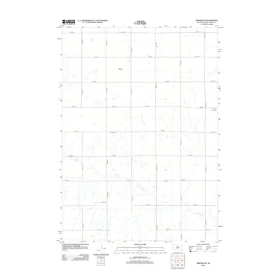
2012 Map of Freeman SE
USGS Topo · Published 2012About this map
The rural landscape of Turner County is defined by a rhythmic grid of sectional roads and the meandering path of Turkey Ridge Cr. This 2012 survey illustrates the enduring agricultural character of the region, where the land is partitioned by routes like 444th Ave and 280th St. Scattered throughout this pastoral expanse are several small burial grounds that serve as focal points for local history and genealogy. These sites, including Salem Zion Cem, Salem Cem, Turkey Valley Cem, and West Cem, are the primary landmarks in an area otherwise dedicated to open fields. The map provides a precise look at the modern rural infrastructure, showing the intersection of long-established section lines with the natural drainage patterns of the creek.
Find a feature on this map
20 named features on this map. Tap any name to fly to it.
Don’t see what you’re looking for? This feature index may not catch every label — zoom into the map to look around manually.
Map Details
Editions of this 2012 Freeman SE Map
This is the sole edition of this map. No revisions or reprints were ever made.
Other maps of this area

1898 · Parker
USGS Topo · 1:125,000

1955 · Sioux Falls
USGS Topo · 1:250,000

1957 · Midway
USGS Topo · 1:24,000

1958 · Sioux Falls
USGS Topo · 1:250,000

1968 · Parker SW
USGS Topo · 1:24,000
1968 · Parker
USGS Topo · 1:24,000

1970 · Turkey Ridge
USGS Topo · 1:24,000

1970 · Freeman SE
USGS Topo · 1:24,000
1970 · Freeman
USGS Topo · 1:24,000
1970 · Center Point
USGS Topo · 1:24,000
Featured Places
- Marion Township, SD
- Rosefield Township, SD
- Spring Valley Township, SD
- Childstown Township, SD
- Salem Township, SD