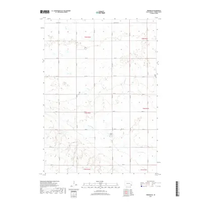
2017 Map of Freeman SE
USGS Topo · Published 2017About this map
Turkey Ridge Creek winds through this section of Turner County, cutting across a landscape defined by its agricultural heritage and rural settlement patterns. The map highlights the foundational role of faith and family in this South Dakota prairie, evidenced by the numerous burial sites that anchor the townships. Genealogists will find particular value in the locations of Salem Zion Cem, the Unruh Family Cem, and West Cem, which serve as quiet landmarks for early settlers. The township grid is clearly delineated, with routes such as S Dakota Hwy 44 and Co Hwy 32 providing the primary arteries through the farmland. These roads connect the disparate farmsteads and cemeteries like Turkey Valley Cem, illustrating the organized expansion and community structure of the late 20th-century Great Plains.
Find a feature on this map
31 named features on this map. Tap any name to fly to it.
Don’t see what you’re looking for? This feature index may not catch every label — zoom into the map to look around manually.
Map Details
Editions of this 2017 Freeman SE Map
This is the sole edition of this map. No revisions or reprints were ever made.
Other maps of this area

1898 · Parker
USGS Topo · 1:125,000

1955 · Sioux Falls
USGS Topo · 1:250,000

1957 · Midway
USGS Topo · 1:24,000

1958 · Sioux Falls
USGS Topo · 1:250,000

1968 · Parker SW
USGS Topo · 1:24,000
1968 · Parker
USGS Topo · 1:24,000

1970 · Turkey Ridge
USGS Topo · 1:24,000

1970 · Freeman SE
USGS Topo · 1:24,000
1970 · Freeman
USGS Topo · 1:24,000
1970 · Center Point
USGS Topo · 1:24,000
Featured Places
- Marion Township, SD
- Rosefield Township, SD
- Spring Valley Township, SD
- Childstown Township, SD
- Salem Township, SD