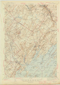
1944 Map of Freeport
USGS Topo · Published 1944About this map
The Androscoggin River defines the northern reaches of this coastal survey, where industrial centers like Lisbon Falls and the paper mill site of Pejepscot stand in contrast to the rural farmsteads of Durham and Pownal. Near the coast, the villages of Yarmouth and South Freeport serve as gateways to the complex maritime landscape of Casco Bay, characterized by protected inlets like the Harraseeket River and Maquoit Bay. Inland, the terrain rises toward Bradbury Mountain, which is already established here as Bradbury Mountain State Park.
Find a feature on this map
182 named features on this map. Tap any name to fly to it.
Don’t see what you’re looking for? This feature index may not catch every label — zoom into the map to look around manually.
Map Details
Editions of this 1944 Freeport Map
3 editions found

Other maps of this area

1891 · Portland
USGS Topo · 1:62,500

1892 · Gardiner
USGS Topo · 1:62,500

1892 · Freeport
USGS Topo · 1:62,500

1893 · Small Point
USGS Topo · 1:62,500

1893 · Portland
USGS Topo · 1:62,500

1893 · Casco Bay
USGS Topo · 1:62,500

1894 · Gray
USGS Topo · 1:62,500

1894 · Bath
USGS Topo · 1:62,500

1898 · Gray
USGS Topo · 1:62,500

1908 · Poland
USGS Topo · 1:62,500