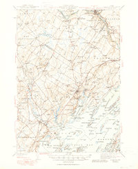
1944 Map of Freeport
USGS Topo · Published 1950About this map
The Androsccogin River winds through the northern reaches of this coastal landscape, powering industry at Lisbon Falls and Pejepscot while defining the border between Androsccogin and Sagadahoc counties. To the south, the intricate shoreline of Casco Bay reveals a maritime economy centered on Maquoit Bay and the Harraseeket River. The 1941 survey documents a transitional era where traditional river-and-rail transport, represented by the Maine Central and Canadian National lines, intersects with early conservation efforts at Bradbury Mountain State Park. Genealogists will find a wealth of local landmarks, from the Plummer Mill on Meadow Brook to numerous family-named burial sites such as the Lunt Memorial Cem and Gerrish Cem. Small rural schools like Hacker Sch and Cedar Sch are scattered among inland settlements like Southwest Bend and Pownal Center, illustrating the decentralized social fabric of mid-century coastal Maine.
Find a feature on this map
185 named features on this map. Tap any name to fly to it.
Don’t see what you’re looking for? This feature index may not catch every label — zoom into the map to look around manually.
Map Details
Editions of this 1944 Freeport Map
3 editions found

Other maps of this area

1891 · Portland
USGS Topo · 1:62,500

1892 · Gardiner
USGS Topo · 1:62,500

1892 · Freeport
USGS Topo · 1:62,500

1893 · Small Point
USGS Topo · 1:62,500

1893 · Portland
USGS Topo · 1:62,500

1893 · Casco Bay
USGS Topo · 1:62,500

1894 · Gray
USGS Topo · 1:62,500

1894 · Bath
USGS Topo · 1:62,500

1898 · Gray
USGS Topo · 1:62,500

1908 · Poland
USGS Topo · 1:62,500