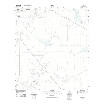
2010 Map of Freer South
USGS Topo · Published 2010About this map
Loma Novia Oil Field and Hoffman Oil Field anchor this south Texas landscape, illustrating the region's enduring reliance on the petroleum industry. Just south of Freer, several residential developments such as Williamson Addition Colonia, George W Ward Addition Number 2 Colonia, and Highway 16 South Colonia reflect the expansion of the town's footprint into the brush country. The terrain is defined by a network of seasonal watercourses, including Rosita Creek and Hoffman Creek, which are managed by federal infrastructure like the Soil Conservation Service Site 9 Dam. Rising above the surrounding flats, Piedritos Hill serves as a prominent natural landmark in a territory primarily organized around county roads and oil extraction sites.
Find a feature on this map
16 named features on this map. Tap any name to fly to it.
Don’t see what you’re looking for? This feature index may not catch every label — zoom into the map to look around manually.
Map Details
Editions of this 2010 Freer South Map
This is the sole edition of this map. No revisions or reprints were ever made.
Other maps of this area

1956 · Benavides
USGS Topo · 1:62,500

1956 · Rosita Ranch
USGS Topo · 1:62,500

1956 · Freer
USGS Topo · 1:62,500

1956 · Laredo
USGS Topo · 1:250,000

1968 · Benavides NW
USGS Topo · 1:24,000

1968 · Parrilla Creek NW
USGS Topo · 1:24,000

1968 · Parrilla Creek NE
USGS Topo · 1:24,000
1968 · Rosita
USGS Topo · 1:24,000
1969 · Rosita NW
USGS Topo · 1:24,000
1971 · Freer North
USGS Topo · 1:24,000