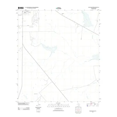
2013 Map of Freer South
USGS Topo · Published 2013About this map
Freer sits at a strategic crossroads in the brush country of Duval County, where the settlement’s northern edge gives way to the open ranching and energy-producing lands of south Texas. The landscape is defined by a dendritic network of ephemeral drainage ways including Rosita Cr and Tarancahuas Cr, which carve through the arid terrain. To the south, the map details the courses of Hoffman Cr and Animas Cr, illustrating the vital water resources in this dry region. This 2013 survey provides a clear view of the modern road network and industrial footprints that define the area's contemporary economy, contrasting the concentrated residential grid of the town with the expansive, sparsely populated territory surrounding it.
Find a feature on this map
5 named features on this map. Tap any name to fly to it.
Don’t see what you’re looking for? This feature index may not catch every label — zoom into the map to look around manually.
Map Details
Editions of this 2013 Freer South Map
This is the sole edition of this map. No revisions or reprints were ever made.
Other maps of this area

1956 · Benavides
USGS Topo · 1:62,500

1956 · Rosita Ranch
USGS Topo · 1:62,500

1956 · Freer
USGS Topo · 1:62,500

1956 · Laredo
USGS Topo · 1:250,000

1968 · Benavides NW
USGS Topo · 1:24,000

1968 · Parrilla Creek NW
USGS Topo · 1:24,000

1968 · Parrilla Creek NE
USGS Topo · 1:24,000
1968 · Rosita
USGS Topo · 1:24,000
1969 · Rosita NW
USGS Topo · 1:24,000
1971 · Freer North
USGS Topo · 1:24,000