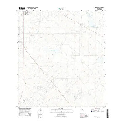
2016 Map of Freer South
USGS Topo · Published 2016About this map
Freer occupies the northwestern corner of this South Texas landscape, where the street grid of the southern town limits transitions into a vast expanse of ranch land and dry creek beds. Residential thoroughfares like Stinson Dr, Rosita Ave, and Magnolia Rd provide a structured anchor against the undulating topography of the surrounding Duval County brush country. The map illustrates a drainage network characterized by seasonal watercourses such as Tarancahuas Cr, Rosita Cr, and Hoffman Cr, which are managed through infrastructure like the Soil Conservation Service Site 7 Reservoir. This rural area is defined by a sparse network of county roads and long stretches of Priv Ranch Rd, occasionally restricted by a Priv Ranch Road, Locked Gate. Local relief is punctuated by prominent natural landmarks like Piedritos Hill, which rises above the complex drainage patterns of Animas Cr N.
Find a feature on this map
25 named features on this map. Tap any name to fly to it.
Don’t see what you’re looking for? This feature index may not catch every label — zoom into the map to look around manually.
Map Details
Editions of this 2016 Freer South Map
This is the sole edition of this map. No revisions or reprints were ever made.
Other maps of this area

1956 · Benavides
USGS Topo · 1:62,500

1956 · Rosita Ranch
USGS Topo · 1:62,500

1956 · Freer
USGS Topo · 1:62,500

1956 · Laredo
USGS Topo · 1:250,000

1968 · Benavides NW
USGS Topo · 1:24,000

1968 · Parrilla Creek NW
USGS Topo · 1:24,000

1968 · Parrilla Creek NE
USGS Topo · 1:24,000
1968 · Rosita
USGS Topo · 1:24,000
1969 · Rosita NW
USGS Topo · 1:24,000
1971 · Freer North
USGS Topo · 1:24,000