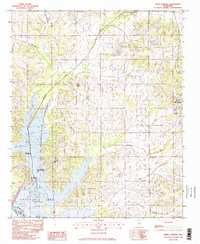
1982 Map of Frees Corners
USGS Topo · Published 1982About this map
Arkabutla Lake dominates the southwestern portion of this landscape, its waters reaching into the Arkabutla State Waterfowl Refuge along the northern banks of the Coldwater River. This 1982 provisional survey captures the rural character of Northern Mississippi, where small communities like Frees Corners and Deans Corner sit atop rolling terrain dissected by numerous watercourses. The drainage patterns of Hurricane Creek and Mussacuna Creek define the local geography, leading toward the reservoir and its developed recreational spots including the Plantation Point Public Use Area. On the eastern edge, the growth of Hernando begins to appear, while specialized agricultural or industrial sites like Robinson Gin reflect the traditional economic footprint of the De Soto Co and Tate Co borderlands.
Find a feature on this map
19 named features on this map. Tap any name to fly to it.
Don’t see what you’re looking for? This feature index may not catch every label — zoom into the map to look around manually.
Map Details
Editions of this 1982 Frees Corners Map
2 editions found
Other maps of this area

1908 · Lake Cormorant
USGS Topo · 1:24,000

1912 · Lake Cormorant
USGS Topo · 1:31,680

1932 · Horn Lake
USGS Topo · 1:48,000

1932 · Crenshaw
USGS Topo · 1:62,500

1935 · Crenshaw
USGS Topo · 1:62,500

1935 · Horn Lake
USGS Topo · 1:62,500

1944 · Senatobia
USGS Topo · 1:62,500

1944 · Hernando
USGS Topo · 1:62,500

1948 · Helena
USGS Topo · 1:250,000

1950 · Helena
USGS Topo · 1:250,000