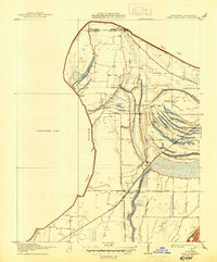
1912 Map of Lake Cormorant
USGS Topo · Published 1945About this map
Old River meanders along the state line in this 1908 survey, defining a landscape of complex waterways and alluvial soils where De Soto County meets the Tennessee border. The Yazoo and Mississippi Valley Railroad serves as a central spine for the region, connecting the settlement at Lake Cormorant to northern points. The mapping reveals a detailed network of drainage and transport including Norfolk Bayou and the Dead Nigger Slough, which were critical to the area's agricultural development overseen by the Tallahatchie Drainage Commission.
Find a feature on this map
15 named features on this map. Tap any name to fly to it.
Don’t see what you’re looking for? This feature index may not catch every label — zoom into the map to look around manually.
Map Details
Editions of this 1912 Lake Cormorant Map
3 editions found
Other maps of this area

1908 · Lake Cormorant
USGS Topo · 1:24,000

1912 · Lake Cormorant
USGS Topo · 1:31,680

1916 · Memphis
USGS Topo · 1:62,500

1925 · Memphis
USGS Topo · 1:48,000

1927 · Memphis
USGS Topo · 1:62,500

1931 · Horseshoe Lake
USGS Topo · 1:62,500

1932 · Horn Lake
USGS Topo · 1:48,000

1935 · Horn Lake
USGS Topo · 1:62,500

1939 · Horseshoe Lake
USGS Topo · 1:62,500

1939 · Edmondson
USGS Topo · 1:62,500