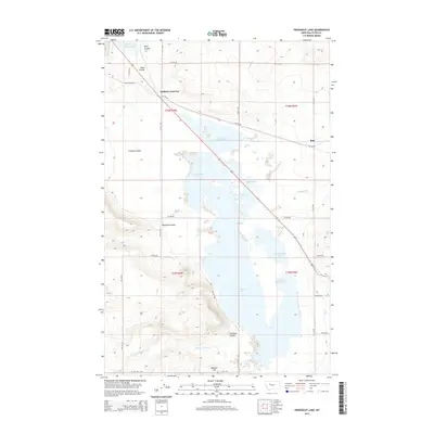
2014 Map of Freezeout Lake
USGS Topo · Published 2014About this map
Freezeout Lake dominates this central Montana landscape, surrounded by an intricate network of numbered ponds and irrigation infrastructure including the N Supply Ditch and Cascade Canal. The map reveals a land shaped by water management and topography, where several large coulees, such as Wolf Coulee, Crossen Coulee, and Roundup Coulee, drain toward the lake basin. The small settlements of Bole and Eastham Junction are situated along the primary roadways that cut through the grid of rural township lines. The terrain is marked by distinctive elevations like Moehler Hill and the Priest Butte Lakes in the northwest, providing a clear look at the agricultural and hydrological layout of Teton County in the early 21st century. Researchers will find a precise record of the regional drainage, from Dipping Tank Cr to the various numbered catchments like Pond Number Five.
Find a feature on this map
36 named features on this map. Tap any name to fly to it.
Don’t see what you’re looking for? This feature index may not catch every label — zoom into the map to look around manually.
Map Details
Editions of this 2014 Freezeout Lake Map
This is the sole edition of this map. No revisions or reprints were ever made.
Other maps of this area

1886 · Great Falls
USGS Topo · 1:250,000

1920 · Choteau
USGS Topo · 1:125,000

1950 · Fairfield
USGS Topo · 1:62,500

1950 · Collins
USGS Topo · 1:62,500

1954 · Great Falls
USGS Topo · 1:250,000

1955 · Choteau
USGS Topo · 1:250,000

1957 · Choteau
USGS Topo · 1:250,000

1957 · Great Falls
USGS Topo · 1:250,000

1958 · Choteau
USGS Topo · 1:250,000

1960 · Choteau
USGS Topo · 1:62,500