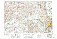
1955 Map of Fremont
USGS Topo · Published 1974About this map
The confluence of the Platte River and the Loup River near Columbus anchors this mid-century portrait of eastern Nebraska and western Iowa. The landscape is defined by the broad river valleys that historically dictated the path of overland travel and settlement, including the Elkhorn River winding toward its junction with the Platte. This 1:250,000 scale survey captures the region during a period of infrastructure expansion, showing the development of Interstate 80 alongside established rail routes like the Union Pacific RR. To the east, the Missouri River carves a complex boundary through the bottomlands, where the De Soto National Wildlife Refuge and Carter Lake mark shifts in the river's historical course. Strategic and recreational sites are prominent, from the presence of Offutt Air Force Base south of Omaha to the irrigation and power reservoirs of Lake Babcock and Lake North. Smaller agricultural hubs like David City, Schuyler, and Osceola are connected by a dense grid of section lines and early highways.
Find a feature on this map
133 named features on this map. Tap any name to fly to it.
Don’t see what you’re looking for? This feature index may not catch every label — zoom into the map to look around manually.
Map Details
Editions of this 1955 Fremont Map
3 editions found

Other maps of this area

1893 · Omaha
USGS Topo · 1:62,500

1893 · Fremont
USGS Topo · 1:125,000

1896 · Stromsburg
USGS Topo · 1:125,000

1896 · Fremont
USGS Topo · 1:125,000

1897 · Lincoln
USGS Topo · 1:125,000

1898 · York
USGS Topo · 1:125,000

1898 · Grand Island
USGS Topo · 1:125,000

1899 · Wahoo
USGS Topo · 1:125,000

1899 · David City
USGS Topo · 1:125,000

1899 · St. Paul
USGS Topo · 1:125,000