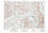
1955 Map of Fremont
USGS Topo · Published 1974About this map
The Platte River valley serves as the central artery for this mid-20th-century landscape, where industrial and agricultural hubs like Fremont and Columbus expanded alongside critical transportation corridors. The mapping illustrates the concentrated development along the Union Pacific and Chicago and North Western railroads, which facilitated the growth of small agricultural stops and grain shipping points. Beyond the primary river valley, the topography is defined by a dense network of tributaries including Shell Creek, Maple Creek, and Beaver Creek, supporting numerous rural settlements from Albion in the northwest to Ashland in the southeast.
Find a feature on this map
156 named features on this map. Tap any name to fly to it.
Don’t see what you’re looking for? This feature index may not catch every label — zoom into the map to look around manually.
Map Details
Editions of this 1955 Fremont Map
3 editions found

Other maps of this area

1893 · Omaha
USGS Topo · 1:62,500

1893 · Fremont
USGS Topo · 1:125,000

1896 · Stromsburg
USGS Topo · 1:125,000

1896 · Fremont
USGS Topo · 1:125,000

1897 · Lincoln
USGS Topo · 1:125,000

1898 · York
USGS Topo · 1:125,000

1898 · Grand Island
USGS Topo · 1:125,000

1899 · Wahoo
USGS Topo · 1:125,000

1899 · David City
USGS Topo · 1:125,000

1899 · St. Paul
USGS Topo · 1:125,000