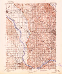
1896 Map of Fremont
USGS Topo · Published 1941About this map
The Platte River and Elkhorn River dominate this late 19th-century landscape, carving wide valleys across eastern Nebraska. Surveyed in 1893, the map illustrates a region defined by its rail-and-river network, where the Union Pacific R.R. and Burlington and Missouri River RR intersect established settlements. Industrial and agricultural hubs like Fremont and Arlington are shown during a period of steady growth, while the eastern edge of the sheet captures the rugged bluffs near the Missouri River at Fort Calhoun. Smaller communities, including Marietta, Memphis, and Portal, are interspersed among the townships of Pohocco and Richland. The detailed township and range grid highlights the structured land division of the era, providing a precise record of historical county boundaries for Dodge Co., Washington Co., and Sarpy Co. before modern expansion altered the rural character of the Omaha and Lincoln corridors.
Find a feature on this map
72 named features on this map. Tap any name to fly to it.
Don’t see what you’re looking for? This feature index may not catch every label — zoom into the map to look around manually.
Map Details
Editions of this 1896 Fremont Map
5 editions found
Other maps of this area

1893 · Omaha
USGS Topo · 1:62,500

1893 · Fremont
USGS Topo · 1:125,000

1896 · Fremont
USGS Topo · 1:125,000

1897 · Lincoln
USGS Topo · 1:125,000

1899 · Wahoo
USGS Topo · 1:125,000

1903 · Weeping Water
USGS Topo · 1:125,000

1929 · Weeping Water
USGS Topo · 1:125,000

1935 · Nehawka
USGS Topo · 1:48,000

1940 · Nehawka
USGS Topo · 1:62,500

1954 · Omaha
USGS Topo · 1:250,000