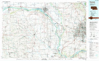
1982 Map of Fremont
USGS Topo · Published 1982About this map
The Platte River valley and its confluence with the Elkhorn River dominate this early 1980s landscape, illustrating the critical transportation and water corridors west of Omaha. The convergence of major rail lines, including the Union Pacific, Burlington Northern, and Chicago and North Western, underscores the region's historical role as a transit hub. Near the western edge of the metropolitan area, Boys Town and several municipal airports like Millard Airport show the suburban expansion into formerly agricultural lands.
Find a feature on this map
140 named features on this map. Tap any name to fly to it.
Don’t see what you’re looking for? This feature index may not catch every label — zoom into the map to look around manually.
Map Details
Editions of this 1982 Fremont Map
2 editions found
Other maps of this area

1893 · Omaha
USGS Topo · 1:62,500

1893 · Fremont
USGS Topo · 1:125,000

1896 · Fremont
USGS Topo · 1:125,000

1897 · Lincoln
USGS Topo · 1:125,000

1899 · Wahoo
USGS Topo · 1:125,000

1899 · David City
USGS Topo · 1:125,000

1903 · Weeping Water
USGS Topo · 1:125,000

1929 · Weeping Water
USGS Topo · 1:125,000

1934 · Seward
USGS Topo · 1:48,000

1935 · Nehawka
USGS Topo · 1:48,000