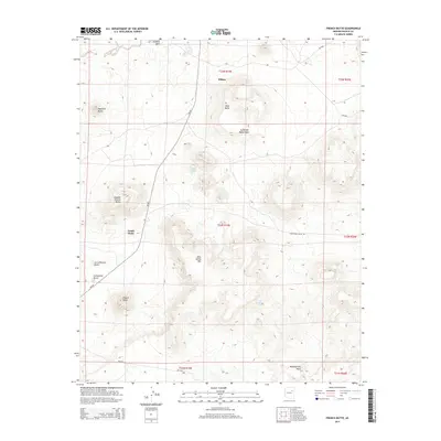
2014 Map of French Butte
USGS Topo · Published 2014About this map
Dilkon serves as the primary settlement on this high-desert landscape, situated near the northern edge of the quadrangle. The terrain is defined by a series of prominent volcanic landforms, including Wide Butte, Haystack Butte, and the namesake French Butte to the south. These landmarks rise sharply from the basin, providing essential geographic markers for travelers and residents. The drainage patterns of Coyote Wash and Sunflower Butte Wash indicate the seasonal water flow that shapes the arid environment, while isolated water sources like Echo Spring and Tode Bito Tsiquini represent critical points of interest in this portion of the Navajo Nation. The road network, primarily composed of Bureau of Indian Affairs routes like Bia-60, connects the scattered geological features and localized springs across the plateau.
Find a feature on this map
26 named features on this map. Tap any name to fly to it.
Don’t see what you’re looking for? This feature index may not catch every label — zoom into the map to look around manually.
Map Details
Editions of this 2014 French Butte Map
This is the sole edition of this map. No revisions or reprints were ever made.
Other maps of this area

1883 · Tusayan
USGS Topo · 1:250,000

1886 · Tusayan
USGS Topo · 1:250,000

1947 · Flagstaff
USGS Topo · 1:250,000

1954 · Flagstaff
USGS Topo · 1:250,000

1958 · Flagstaff
USGS Topo · 1:250,000

1960 · Flagstaff
USGS Topo · 1:250,000

1962 · Flagstaff
USGS Topo · 1:250,000
1967 · Dilkon
USGS Topo · 1:24,000
1967 · French Butte
USGS Topo · 1:24,000
1967 · Chimney Butte
USGS Topo · 1:24,000