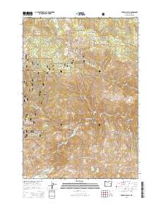
2014 Map of French Gulch
USGS Topo · Published 2014About this map
The Burnt River carves a deep path through this corner of Baker County, anchoring a landscape defined by the expansive Whitman National Forest. In the southwest, the Bridgeport Valley provides a rare stretch of level ground near the junction of Clarks Cr and Marble Cr. The terrain is characterized by high-elevation landmarks such as Chicken Peak and Stump Spring Butte, with numerous springs—including the Ridge Top Spring Number Four series—providing critical water sources across the higher ridges. Evidence of water management and varied topography is seen in features like Bennett Reservoir and the appropriately named Dead Horse Canyon. This 2014 survey documents the complex network of Forest Service routes, such as NFD RD 020 RD, that navigate the gulches and canyons north of the river.
Find a feature on this map
58 named features on this map. Tap any name to fly to it.
Don’t see what you’re looking for? This feature index may not catch every label — zoom into the map to look around manually.
Map Details
Editions of this 2014 French Gulch Map
This is the sole edition of this map. No revisions or reprints were ever made.
Other maps of this area

1901 · Baker City
USGS Topo · 1:125,000

1955 · Baker
USGS Topo · 1:250,000

1959 · Baker
USGS Topo · 1:250,000

1964 · Bridgeport
USGS Topo · 1:62,500

1964 · Ironside
USGS Topo · 1:62,500

1967 · Encina
USGS Topo · 1:24,000

1967 · French Gulch
USGS Topo · 1:24,000

1967 · Dooley Mtn
USGS Topo · 1:24,000

1967 · Lost Basin
USGS Topo · 1:24,000
1967 · Bowen Valley
USGS Topo · 1:24,000