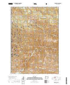
2020 Map of French Gulch
USGS Topo · Published 2020About this map
Bridgeport Valley occupies the southwestern corner of this Baker County landscape, where Clarks Cr and Marble Cr converge at the foot of the hills. Much of the central and northern terrain is managed as part of the Whitman National Forest, a territory defined by high summits like Chicken Peak and steep-sided drainages including Dead Horse Canyon and French Gulch.
Find a feature on this map
57 named features on this map. Tap any name to fly to it.
Don’t see what you’re looking for? This feature index may not catch every label — zoom into the map to look around manually.
Map Details
Editions of this 2020 French Gulch Map
This is the sole edition of this map. No revisions or reprints were ever made.
Other maps of this area

1901 · Baker City
USGS Topo · 1:125,000

1955 · Baker
USGS Topo · 1:250,000

1959 · Baker
USGS Topo · 1:250,000

1964 · Bridgeport
USGS Topo · 1:62,500

1964 · Ironside
USGS Topo · 1:62,500

1967 · Encina
USGS Topo · 1:24,000

1967 · French Gulch
USGS Topo · 1:24,000

1967 · Dooley Mtn
USGS Topo · 1:24,000

1967 · Lost Basin
USGS Topo · 1:24,000
1967 · Bowen Valley
USGS Topo · 1:24,000