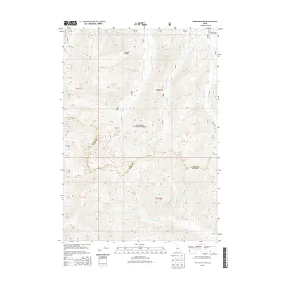
2013 Map of Frenchman Creek
USGS Topo · Published 2013About this map
Vienna stands as a focal point of human history in this mountainous Idaho landscape, situated within the high-elevation reaches of the Sawtooth National Forest. This 2013 survey illustrates the complex drainage patterns of the Sawtooth Range, where headwaters like Frenchman Cr and Smiley Cr feed into the northern-flowing Salmon River. The terrain is marked by significant topographical shifts, moving from the open Sawtooth Valley into steep drainages such as Sawmill Canyon and Mill Gulch. Access to this remote region is primarily facilitated by Smiley Creek Rd, which follows the contours of the land. The map also delineates the high ridgeline boundary shared between Camas and Blaine Counties, tracing the physical divide that separates the W Fork Big Smoky Cr watershed from the interior forest basins.
Find a feature on this map
34 named features on this map. Tap any name to fly to it.
Don’t see what you’re looking for? This feature index may not catch every label — zoom into the map to look around manually.
Map Details
Editions of this 2013 Frenchman Creek Map
This is the sole edition of this map. No revisions or reprints were ever made.
Other maps of this area

1900 · Sawtooth
USGS Topo · 1:125,000

1955 · Hailey
USGS Topo · 1:250,000

1959 · Hailey
USGS Topo · 1:250,000

1962 · Hailey
USGS Topo · 1:250,000

1963 · Alturas Lake
USGS Topo · 1:24,000

1964 · Frenchman Creek
USGS Topo · 1:24,000
1964 · Snowyside Peak
USGS Topo · 1:24,000

1964 · Marshall Peak
USGS Topo · 1:24,000
1970 · Horton Peak
USGS Topo · 1:24,000

1970 · Paradise Peak
USGS Topo · 1:24,000