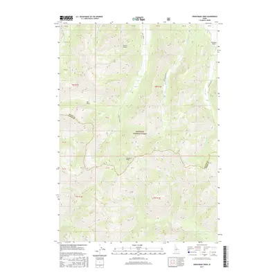
2017 Map of Frenchman Creek
USGS Topo · Published 2017About this map
The Salmon River flows through this high-altitude landscape where the Sawtooth Range meets the Sawtooth Valley. This 2017 topographic study highlights the dramatic drainage systems within the Sawtooth National Forest, specifically detailing the headwaters of Frenchman Cr and Smiley Creek. These waterways were central to the area's development, evidenced by names like Sawmill Canyon and Mill Gulch which suggest early timber and milling activity. The map clearly delineates the border between Blaine County and Camas County, showing how the political boundary follows the high ridgelines of the divide. For researchers, the map provides a precise look at the primitive transport routes such as Smiley Creek Rd and Frenchman Creek Rd that follow these narrow valley floors through the wilderness.
Find a feature on this map
34 named features on this map. Tap any name to fly to it.
Don’t see what you’re looking for? This feature index may not catch every label — zoom into the map to look around manually.
Map Details
Editions of this 2017 Frenchman Creek Map
This is the sole edition of this map. No revisions or reprints were ever made.
Other maps of this area

1900 · Sawtooth
USGS Topo · 1:125,000

1955 · Hailey
USGS Topo · 1:250,000

1959 · Hailey
USGS Topo · 1:250,000

1962 · Hailey
USGS Topo · 1:250,000

1963 · Alturas Lake
USGS Topo · 1:24,000

1964 · Frenchman Creek
USGS Topo · 1:24,000
1964 · Snowyside Peak
USGS Topo · 1:24,000

1964 · Marshall Peak
USGS Topo · 1:24,000
1970 · Horton Peak
USGS Topo · 1:24,000

1970 · Paradise Peak
USGS Topo · 1:24,000