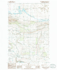
1986 Map of Frenchman Hills Lake
USGS Topo · Published 1986About this map
Frenchman Hills Lake sits at the heart of this mid-1980s Grant County landscape, where the high desert terrain is defined by complex water management and agriculture. The map illustrates a transitional period for the Royal Slope, as irrigation infrastructure like the Frenchman Hills Wasteway and the Frenchman Hills Pumping Plant transformed the arid environment. To the south, the grid of Royal City is visible near the Royal Substation, surrounded by numerous Storage Bins that hint at the region’s productive farming output. Conservation and utility coincide here, with the Desert Habitat Management Area bordering the wasteway and a massive Transmission Line cutting across the Frenchman Hills. Researchers can trace the layout of early landing strips and local industrial features like a Borrow Pit and Sewage Disposal Ponds that supported the growing community.
Find a feature on this map
21 named features on this map. Tap any name to fly to it.
Don’t see what you’re looking for? This feature index may not catch every label — zoom into the map to look around manually.
Map Details
Editions of this 1986 Frenchman Hills Lake Map
This is the sole edition of this map. No revisions or reprints were ever made.
Other maps of this area

1910 · Winchester
USGS Topo · 1:62,500

1911 · Red Rock
USGS Topo · 1:62,500

1912 · Moses Lake
USGS Topo · 1:62,500

1923 · Corfu
USGS Topo · 1:62,500

1950 · Smyrna
USGS Topo · 1:62,500

1951 · Smyrna
USGS Topo · 1:62,500

1951 · Corfu
USGS Topo · 1:62,500

1953 · Walla Walla
USGS Topo · 1:250,000

1953 · Ritzville
USGS Topo · 1:250,000

1956 · Mae
USGS Topo · 1:24,000