1956 Map of Mae
USGS Topo · Published 1957About this map
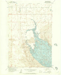
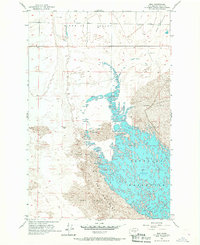
Potholes Reservoir dominates the eastern half of this landscape, its complex shoreline and island-dotted waters reflecting the mid-century transformation of the Columbia Basin. Surveyed by the USBR and USGS during the mid-1950s, the map illustrates the dramatic meeting of water and desert, where the rising reservoir levels began to fill the depressions of The Potholes and press against extensive fields of Sand Dunes.
Find a feature on this map
10 named features on this map. Tap any name to fly to it.
Don’t see what you’re looking for? This feature index may not catch every label — zoom into the map to look around manually.
Map Details
Editions of this 1956 Mae Map

Other maps of this area
1910 · Winchester
USGS Topo · 1:62,500

1911 · Red Rock
USGS Topo · 1:62,500
1912 · Moses Lake
USGS Topo · 1:62,500

1923 · Corfu
USGS Topo · 1:62,500

1950 · Smyrna
USGS Topo · 1:62,500

1951 · Smyrna
USGS Topo · 1:62,500

1951 · Corfu
USGS Topo · 1:62,500

1953 · Walla Walla
USGS Topo · 1:250,000

1953 · Ritzville
USGS Topo · 1:250,000

1956 · Moses Lake South
USGS Topo · 1:24,000