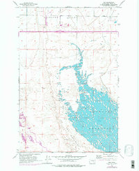
1956 Map of Mae
USGS Topo · Published 1978About this map
Potholes Reservoir dominates the eastern landscape of this Grant County survey, showing the water level recorded at Elevation 1039 June 1956. The terrain is defined by the complex interaction of the rising reservoir waters and The Potholes, where countless small islands and inlets emerge from the submerged Sand Dunes. To the north, the small settlement of Mae sits near a local cemetery, while the wider Hiawatha Valley provides a contrast of flat, developable land against the shifting topography of the dunes.
Find a feature on this map
11 named features on this map. Tap any name to fly to it.
Don’t see what you’re looking for? This feature index may not catch every label — zoom into the map to look around manually.
Map Details
Editions of this 1956 Mae Map

Other maps of this area

1910 · Winchester
USGS Topo · 1:62,500

1911 · Red Rock
USGS Topo · 1:62,500

1912 · Moses Lake
USGS Topo · 1:62,500

1923 · Corfu
USGS Topo · 1:62,500

1950 · Smyrna
USGS Topo · 1:62,500

1951 · Smyrna
USGS Topo · 1:62,500

1951 · Corfu
USGS Topo · 1:62,500

1953 · Walla Walla
USGS Topo · 1:250,000

1953 · Ritzville
USGS Topo · 1:250,000

1956 · Moses Lake South
USGS Topo · 1:24,000