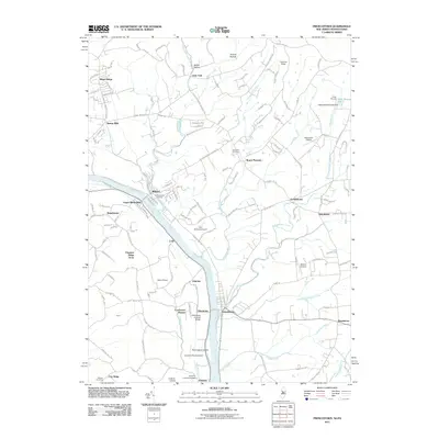
2011 Map of Frenchtown
USGS Topo · Published 2011About this map
The Delaware River forms a natural border through this landscape, separating New Jersey settlements like Frenchtown and Milford from their Pennsylvania counterparts. The river valley is defined by significant historical infrastructure, notably the Uhlerstown Covered Bridge and the Erwinna Covered Bridge, which serve as tangible links to the region's 19th-century transit patterns. This survey reveals a high density of small-scale aviation, with five distinct landing strips including Alexandria Airport and Erkes Airport dotting the countryside.
Find a feature on this map
107 named features on this map. Tap any name to fly to it.
Don’t see what you’re looking for? This feature index may not catch every label — zoom into the map to look around manually.
Map Details
Editions of this 2011 Frenchtown Map
This is the sole edition of this map. No revisions or reprints were ever made.
Other maps of this area

1890 · Easton
USGS Topo · 1:62,500

1890 · High Bridge
USGS Topo · 1:62,500

1890 · Lambertville
USGS Topo · 1:62,500

1890 · Doylestown
USGS Topo · 1:62,500

1891 · Easton
USGS Topo · 1:62,500

1891 · Lambertville
USGS Topo · 1:62,500

1891 · Doylestown
USGS Topo · 1:62,500
1894 · Lambertville
USGS Topo · 1:62,500
1898 · High Bridge
USGS Topo · 1:62,500
1900 · Raritan
USGS Topo · 1:125,000