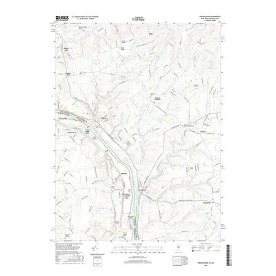
2016 Map of Frenchtown
USGS Topo · Published 2016About this map
The Delaware River serves as the central artery and state boundary in this 2016 survey, dividing the riverside communities of Frenchtown, Milford, and Lodi in New Jersey from Uhlerstown, Erwinna, and Upper Black Eddy in Pennsylvania. This corridor preserves significant historic infrastructure, most notably the Uhlerstown Covered Bridge and Erwinna Covered Bridge, which stand as landmarks of traditional craftsmanship along the canal-side roads. The terrain transitions from the heights of Musconetcong Mtn and Riegel Ridge in the north toward the expansive river bottomlands surrounding Pennington Island. Local history and genealogy are well-represented through several traditional burial sites, including the Pursell Burying Ground and Milford Union Cem. Smaller crossroads settlements such as Everittstown, Baptistown, and Little York are connected by a network of rural routes like Co RD 519, illustrating the long-standing agricultural and residential patterns of Hunterdon Co and Bucks Co.
Find a feature on this map
143 named features on this map. Tap any name to fly to it.
Don’t see what you’re looking for? This feature index may not catch every label — zoom into the map to look around manually.
Map Details
Editions of this 2016 Frenchtown Map
This is the sole edition of this map. No revisions or reprints were ever made.
Other maps of this area

1890 · Easton
USGS Topo · 1:62,500

1890 · High Bridge
USGS Topo · 1:62,500

1890 · Lambertville
USGS Topo · 1:62,500

1890 · Doylestown
USGS Topo · 1:62,500

1891 · Easton
USGS Topo · 1:62,500

1891 · Lambertville
USGS Topo · 1:62,500

1891 · Doylestown
USGS Topo · 1:62,500

1894 · Lambertville
USGS Topo · 1:62,500

1898 · High Bridge
USGS Topo · 1:62,500

1900 · Raritan
USGS Topo · 1:125,000