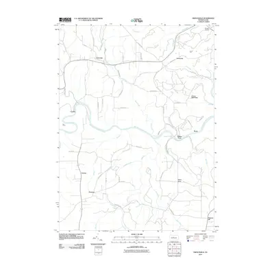
2010 Map of Frenchville
USGS Topo · Published 2010About this map
Frenchville and the winding West Branch Susquehanna River anchor this rural portrait of Clearfield County. The landscape is defined by the deep dissection of the Allegheny Plateau, where numerous runs and creeks have carved a complex network of ridges. Several small, historically significant nodes are scattered throughout the territory, including Keewaydin, Sylvan Grove, and the uniquely named Guenot Settlement.
Find a feature on this map
60 named features on this map. Tap any name to fly to it.
Don’t see what you’re looking for? This feature index may not catch every label — zoom into the map to look around manually.
Map Details
Editions of this 2010 Frenchville Map
This is the sole edition of this map. No revisions or reprints were ever made.
Other maps of this area

1903 · Houtzdale
USGS Topo · 1:62,500

1905 · Houtzdale
USGS Topo · 1:62,500

1922 · Philipsburg
USGS Topo · 1:62,500

1929 · Karthaus
USGS Topo · 1:62,500

1929 · Clearfield
USGS Topo · 1:48,000

1932 · Clearfield
USGS Topo · 1:62,500

1932 · Karthaus
USGS Topo · 1:62,500

1939 · Philipsburg
USGS Topo · 1:62,500

1945 · Philipsburg
USGS Topo · 1:62,500
1945 · Wallaceton
USGS Topo · 1:24,000
Featured Places
- Karthaus Township, PA
- Cooper Township, PA
- Frenchville, Covington Township
- Pleasant Hill, Cooper Township
- Coudley, Girard Township