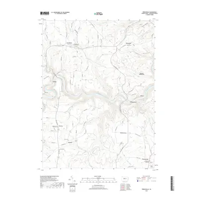
2019 Map of Frenchville
USGS Topo · Published 2019About this map
Frenchville and surrounding rural settlements are defined by the deep winding path of the West Branch Susquehanna River as it cuts through the plateau. This 2019 data illustrates a landscape of high ridges and narrow hollows, where small communities like Keewaydin, Palestine, and Sylvan Grove are linked by winding roads such as Caledonia Pike and Frenchville Rd. The area is notably dense with cemetery sites, including Saint Mary of the Assumption Cem and Keewaydin Cem, providing a detailed record of the region's long-established families and parish history. To the south, Folmar Airport sits near Pleasant Hill, while the remote character of the northern hills is preserved through labels like Guenot Settlement and the Gated Game Land 4WD Trl. Numerous tributaries, such as Alder Run, Big Run, and Sandy Cr, feed the river, carving the complex topography that has shaped local development for generations.
Find a feature on this map
86 named features on this map. Tap any name to fly to it.
Don’t see what you’re looking for? This feature index may not catch every label — zoom into the map to look around manually.
Map Details
Editions of this 2019 Frenchville Map
This is the sole edition of this map. No revisions or reprints were ever made.
Other maps of this area

1903 · Houtzdale
USGS Topo · 1:62,500

1905 · Houtzdale
USGS Topo · 1:62,500

1922 · Philipsburg
USGS Topo · 1:62,500

1929 · Karthaus
USGS Topo · 1:62,500

1929 · Clearfield
USGS Topo · 1:48,000

1932 · Clearfield
USGS Topo · 1:62,500

1932 · Karthaus
USGS Topo · 1:62,500

1939 · Philipsburg
USGS Topo · 1:62,500

1945 · Philipsburg
USGS Topo · 1:62,500
1945 · Wallaceton
USGS Topo · 1:24,000
Featured Places
- Karthaus Township, PA
- Cooper Township, PA
- Frenchville, Covington Township
- Pleasant Hill, Cooper Township
- Coudley, Girard Township