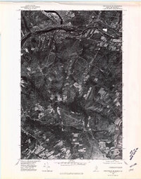
1975 Map of Frenchville SE
USGS Topo · Published 1981About this map
The St John River defines the international boundary between the Canada United States border on this 1975 orthophotograph, providing a detailed look at the industrial and agricultural landscape of northern Maine and New Brunswick. The urban centers of Madawaska and Edmundston dominate the northern corridor, where the river serves as both a geographic divide and a shared resource. To the south, the terrain shifts into a series of long, rectangular agricultural clearings and woodlots characteristic of the region's land use patterns, leading toward Long Lake near the settlement of Cleveland. Local crossroads like Dionne Corner and Fournier anchor the rural infrastructure between the river and the southern lakes. This U.S. Geological Survey imagery offers a precise view of the cross-border connectivity and land parceling along the New Brunswick Maine border during the mid-1970s.
Find a feature on this map
10 named features on this map. Tap any name to fly to it.
Don’t see what you’re looking for? This feature index may not catch every label — zoom into the map to look around manually.
Map Details
Editions of this 1975 Frenchville SE Map
This is the sole edition of this map. No revisions or reprints were ever made.
Other maps of this area

1927 · Stockholm
USGS Topo · 1:48,000

1927 · Square Lake
USGS Topo · 1:48,000

1931 · Square Lake
USGS Topo · 1:62,500

1931 · Stockholm
USGS Topo · 1:62,500

1932 · Frenchville
USGS Topo · 1:48,000

1935 · Frenchville
USGS Topo · 1:62,500

1938 · Grand Isle
USGS Topo · 1:62,500

1940 · Grand Isle
USGS Topo · 1:62,500

1953 · Stockholm
USGS Topo · 1:62,500

1953 · Square Lake
USGS Topo · 1:62,500