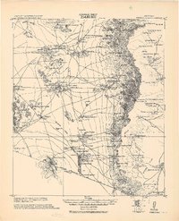
1943 Map of Fresnal
USGS Topo · Published 1943About this map
The Papago Indian Res. dominates this southern Arizona landscape, illustrating the complex settlement patterns and traditional land use of the Tohono O'odham people in the mid-20th century. Highlighting the area's spiritual and geographic heart is Baboquivari Pk, a prominent landmark that towers over the surrounding Sasabe flats and Artesa Mts. The map reveals a network of indigenous villages such as Indian Oasis, Little Tucson, and Topawa, often centered around missions and schools like the Presbyterian Mission & School.
Find a feature on this map
82 named features on this map. Tap any name to fly to it.
Don’t see what you’re looking for? This feature index may not catch every label — zoom into the map to look around manually.
Map Details
Editions of this 1943 Fresnal Map
This is the sole edition of this map. No revisions or reprints were ever made.
Other maps of this area
1920 · Arivaca
USGS Topo · 1:125,000
1921 · Old Glory
USGS Topo · 1:125,000
1934 · Tucson Mountains
USGS Topo · 1:125,000
1934 · Silver Bell
USGS Topo · 1:125,000
1937 · Comobabi
USGS Topo · 1:48,000
1938 · San Vicente
USGS Topo · 1:62,500
1940 · Palo Alto Ranch
USGS Topo · 1:62,500
1941 · Presumido Peak
USGS Topo · 1:62,500
1941 · San Vicente
USGS Topo · 1:62,500
1941 · Cocoraque Butte
USGS Topo · 1:62,500