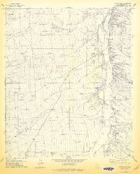
1978 Map of Fresno Wash
USGS Topo · Published 1978About this map
Fresno Wash and the wider Altar Wash valley dominate this Pima County landscape, where an intricate network of seasonal drainages defines the settlement patterns of the late 1970s. The map illustrates a ranching economy dependent on dispersed water sources, visible through numerous named catchments like Pozo Hondo Tank, Espinosa Tank, and Pajonal Tank. Human activity is concentrated around established outposts such as Espinosa Ranch and Pozo Nuevo Ranch, while the presence of San Rafael Wells and a Gaging Station on Altar Wash points to the critical management of water in this arid environment. Transportation is primarily limited to unimproved roads and a remote Landing Strip, underscoring the area's isolation. Geographic landmarks like the volcanic-named Cerro Prieto rise above the alluvial plains, providing distinct points of navigation between Chiltepines Wash and Brown Wash.
Find a feature on this map
37 named features on this map. Tap any name to fly to it.
Don’t see what you’re looking for? This feature index may not catch every label — zoom into the map to look around manually.
Map Details
Editions of this 1978 Fresno Wash Map
This is the sole edition of this map. No revisions or reprints were ever made.
Other maps of this area

1920 · Arivaca
USGS Topo · 1:125,000

1940 · Palo Alto Ranch
USGS Topo · 1:62,500

1941 · Presumido Peak
USGS Topo · 1:62,500

1941 · Baboquivari Peak
USGS Topo · 1:62,500

1941 · Arivaca
USGS Topo · 1:62,500

1943 · Fresnal
USGS Topo · 1:125,000

1943 · Arivaca
USGS Topo · 1:62,500

1943 · Palo Alto Ranch
USGS Topo · 1:62,500

1943 · Presumido Peak
USGS Topo · 1:62,500

1944 · Baboquivari Peak
USGS Topo · 1:62,500