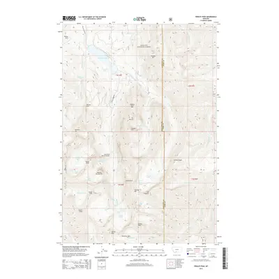
2014 Map of Fridley Peak
USGS Topo · Published 2014About this map
Gallatin National Forest encompasses this high-elevation mountain environment, dominated by the peaks and drainages of the Gallatin Range. At the center of the regional hydrology is Hyalite Reservoir, which collects waters from numerous alpine tributaries including Hyalite Cr and Maid of the Mist Cr. The landscape is defined by its dramatic verticality, containing numerous cascades such as Palisade Falls, Grotto Falls, and Silken Skein Falls. Notable geological features include the Arch Falls Natural Bridge and distinctively named summits like Sleeping Giant Mtn and The Mummy. Higher elevations reveal a network of glacial tarns, including Hyalite Lake and the Fridley Lakes, situated beneath the prominent Fridley Peak and Hyalite Peak. A single primary corridor, Hyalite Canyon Rd, provides access into this complex system of ridges and basins along the Gallatin and Park County border.
Find a feature on this map
67 named features on this map. Tap any name to fly to it.
Don’t see what you’re looking for? This feature index may not catch every label — zoom into the map to look around manually.
Map Details
Editions of this 2014 Fridley Peak Map
This is the sole edition of this map. No revisions or reprints were ever made.
Other maps of this area

1888 · Three Forks
USGS Topo · 1:250,000

1891 · Livingston
USGS Topo · 1:250,000

1893 · Livingston
USGS Topo · 1:250,000

1894 · Three Forks
USGS Topo · 1:250,000

1895 · Three Forks
USGS Topo · 1:250,000

1947 · Bozeman
USGS Topo · 1:250,000

1948 · Bozeman
USGS Topo · 1:250,000

1951 · Bozeman Pass
USGS Topo · 1:62,500

1953 · Bozeman
USGS Topo · 1:62,500

1955 · Bozeman
USGS Topo · 1:250,000