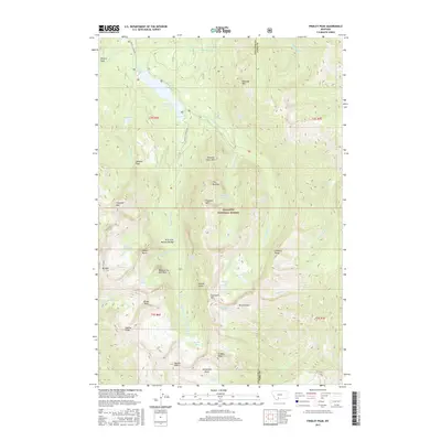
2017 Map of Fridley Peak
USGS Topo · Published 2017About this map
Fridley Peak and Hyalite Peak anchor the southern reaches of the Gallatin Range on this modern survey of high-elevation Montana wilderness. The landscape is defined by its complex drainage systems, where Hyalite Cr and its various forks feed numerous waterfalls, including Palisades Falls, Horsetail Falls, and Grotto Falls. The terrain is marked by distinctive geological features such as History Rock, The Mummy, and the Arch Falls Natural Bridge. Transportation into the high country is facilitated by Hyalite Canyon Rd, which serves as a primary access point to the Gallatin National Forest. The map captures a region dominated by peaks exceeding 10,000 feet, featuring alpine basins like Horseshoe Basin and remote water bodies including Heather Lake and Crescent Lake. These names reflect both the descriptive and whimsical nature of local mountain nomenclature, such as Cupids Heart and Sleeping Giant Mtn.
Find a feature on this map
65 named features on this map. Tap any name to fly to it.
Don’t see what you’re looking for? This feature index may not catch every label — zoom into the map to look around manually.
Map Details
Editions of this 2017 Fridley Peak Map
This is the sole edition of this map. No revisions or reprints were ever made.
Other maps of this area

1888 · Three Forks
USGS Topo · 1:250,000

1891 · Livingston
USGS Topo · 1:250,000

1893 · Livingston
USGS Topo · 1:250,000

1894 · Three Forks
USGS Topo · 1:250,000

1895 · Three Forks
USGS Topo · 1:250,000

1947 · Bozeman
USGS Topo · 1:250,000

1948 · Bozeman
USGS Topo · 1:250,000

1951 · Bozeman Pass
USGS Topo · 1:62,500

1953 · Bozeman
USGS Topo · 1:62,500

1955 · Bozeman
USGS Topo · 1:250,000