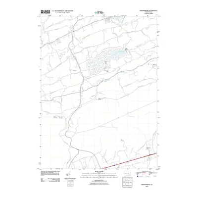
2010 Map of Friedensburg
USGS Topo · Published 2010About this map
Fort Northkill stands as a significant historical marker in this landscape, situated near the headwaters of Little Northkill Creek. The terrain is defined by the prominent ridges of Blue Mountain Rd and Schuylkill Mountain Rd, which channel numerous tributaries including Bear Creek and Birch Creek toward the Schuylkill River in the northeast. Small residential pockets such as Reedsville, Summer Hill, and Jefferson are linked by a network of valley roads like Deiberts Valley Rd. Modern recreational footprints are evident at Camp Blue Mountain and the Pennsylvania Dutch Campground, while the developed waters of Fawn Lake and the Lake Wynonah Dam illustrate 21st-century residential and water management patterns. The map captures a mix of dense forest, riparian corridors, and suburban expansion typical of this region of Pennsylvania.
Find a feature on this map
65 named features on this map. Tap any name to fly to it.
Don’t see what you’re looking for? This feature index may not catch every label — zoom into the map to look around manually.
Map Details
Editions of this 2010 Friedensburg Map
This is the sole edition of this map. No revisions or reprints were ever made.
Other maps of this area

1889 · Pottsville
USGS Topo · 1:62,500

1891 · Pottsville
USGS Topo · 1:62,500

1891 · Lebanon
USGS Topo · 1:62,500

1892 · Pine Grove
USGS Topo · 1:62,500

1893 · Lebanon
USGS Topo · 1:62,500

1899 · Lebanon
USGS Topo · 1:62,500

1902 · Wernersville
USGS Topo · 1:62,500

1943 · Lebanon
USGS Topo · 1:62,500

1943 · Wernersville
USGS Topo · 1:62,500

1944 · Pottsville
USGS Topo · 1:24,000
Featured Places
- Bethel Township, PA
- Friedensburg, Wayne Township
- Upper Tulpehocken Township, PA
- North Manheim Township, PA
- Upper Bern Township, PA