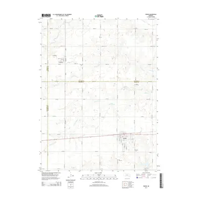
2014 Map of Friend
USGS Topo · Published 2014About this map
Friend and Cordova anchor this 2014 survey of the Nebraska prairie, situated along the county lines where Seward, Saline, Fillmore, and York meet. The landscape is defined by the dendritic drainage patterns of Indian Cr and the various branches of Johnson Creek, including the S Fork Johnson Cr and N Fork Johnson Cr. This agricultural region is meticulously partitioned by a grid of rural roads like Yankee Hill Rd and Saltillo Rd, while the east-west corridor of Us-6 serves as the primary transportation artery through the town of Friend.
Find a feature on this map
58 named features on this map. Tap any name to fly to it.
Don’t see what you’re looking for? This feature index may not catch every label — zoom into the map to look around manually.
Map Details
Editions of this 2014 Friend Map
This is the sole edition of this map. No revisions or reprints were ever made.
Other maps of this area

1934 · Seward
USGS Topo · 1:48,000

1934 · Utica
USGS Topo · 1:62,500

1935 · Dorchester
USGS Topo · 1:48,000

1937 · Utica
USGS Topo · 1:62,500

1939 · Seward
USGS Topo · 1:62,500

1940 · Dorchester
USGS Topo · 1:62,500

1955 · Lincoln
USGS Topo · 1:250,000

1957 · Lincoln
USGS Topo · 1:250,000

1958 · Lincoln
USGS Topo · 1:250,000
1964 · Goehner
USGS Topo · 1:24,000